Technologies
RTT is considered as an element of remote sensing of the Earth, a passive method based on the registration of the Earth's emitted thermal energy (in the form of endogenous thermal flux), which is represented by a continuous spectrum of electromagnetic waves and expressed by a physical parameter called radiobrightness temperature. The radiation can be received by the antenna system (detector, optical, or radio-electronic) at the input. The term "Radio-Thermal Imaging Technologies" itself reveals the ranges of the Earth's electromagnetic radiation used: radio, infrared, and optical.
Essentially, these are technical vision technologies that form images with long wavelengths (radio waves). The longer the wavelength of the radiometric receivers, the higher the efficiency of receiving radiobrightness temperature from the subsurface of the Earth.
The radiobrightness temperature of each resulting pixel is characterized by the temperature of effectiveness and the emission coefficients of specific elements of geological structures.
RTT technologies involve the use of not true values of temperature gradients, but their differentiable contrasts and the density of thermal flux, allowing for the calculation and visualization of all the heterogeneities of the Earth's crust.
The contrast scale has a higher discreteness of relative values: hot and cold. Relative, due to the fact that, in some cases, for a clearer representation of information, inversion is performed, resulting in the scale changing its value to the opposite.
Hot and cold also have a relative meaning and depend on the emission coefficient of each physical object (geological structural heterogeneities) through which electromagnetic waves generated by the Earth's core pass (a broad continuous spectrum with the emission of noise temperatures around 6400 K). A sharp change in radiobrightness temperatures suggests the presence of a boundary of geological structural heterogeneity.
One of the penetration factors (depth) is the ability to increase the sensitivity of radio-thermal space scenes, allowing for the formation of images beneath the Earth's surface.
The use of correction algorithms for raw materials allows eliminating the influence of the landscape surface (vegetation, road network, hydro network, etc.) - the skin layer on the results of the work. The application of algorithms to enhance the sensitivity of the original radiometric scenes (images), algorithms for building a volumetric model (3D cube) of the geological environment allows the formation of block layers of radiometric images at a specified depth, obtaining the depth effect of 'transparency.' Sequential sub-horizontal 'transparency' of the Earth's thickness is a kind of 'X-ray,' but only in the microwave radio range.
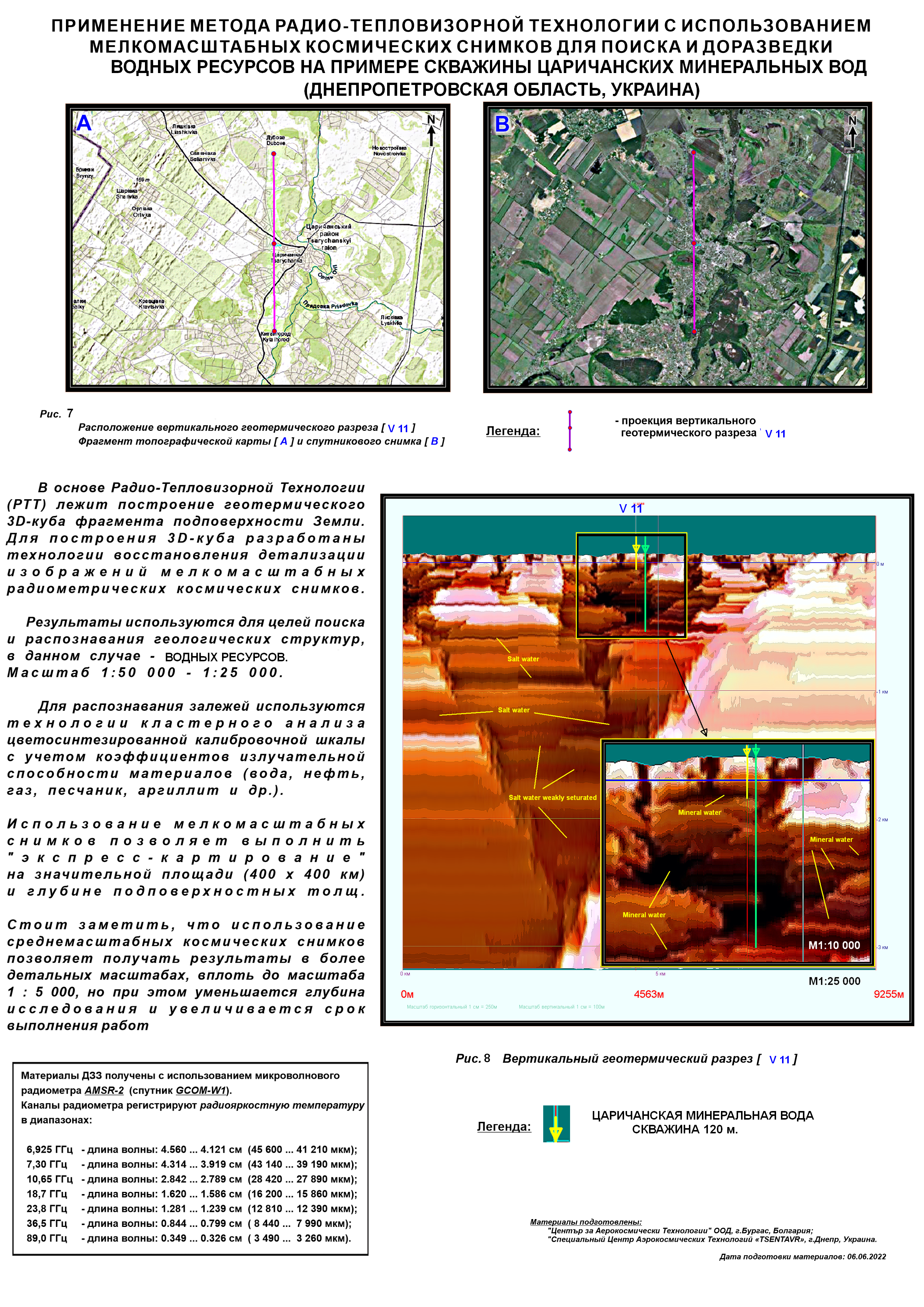
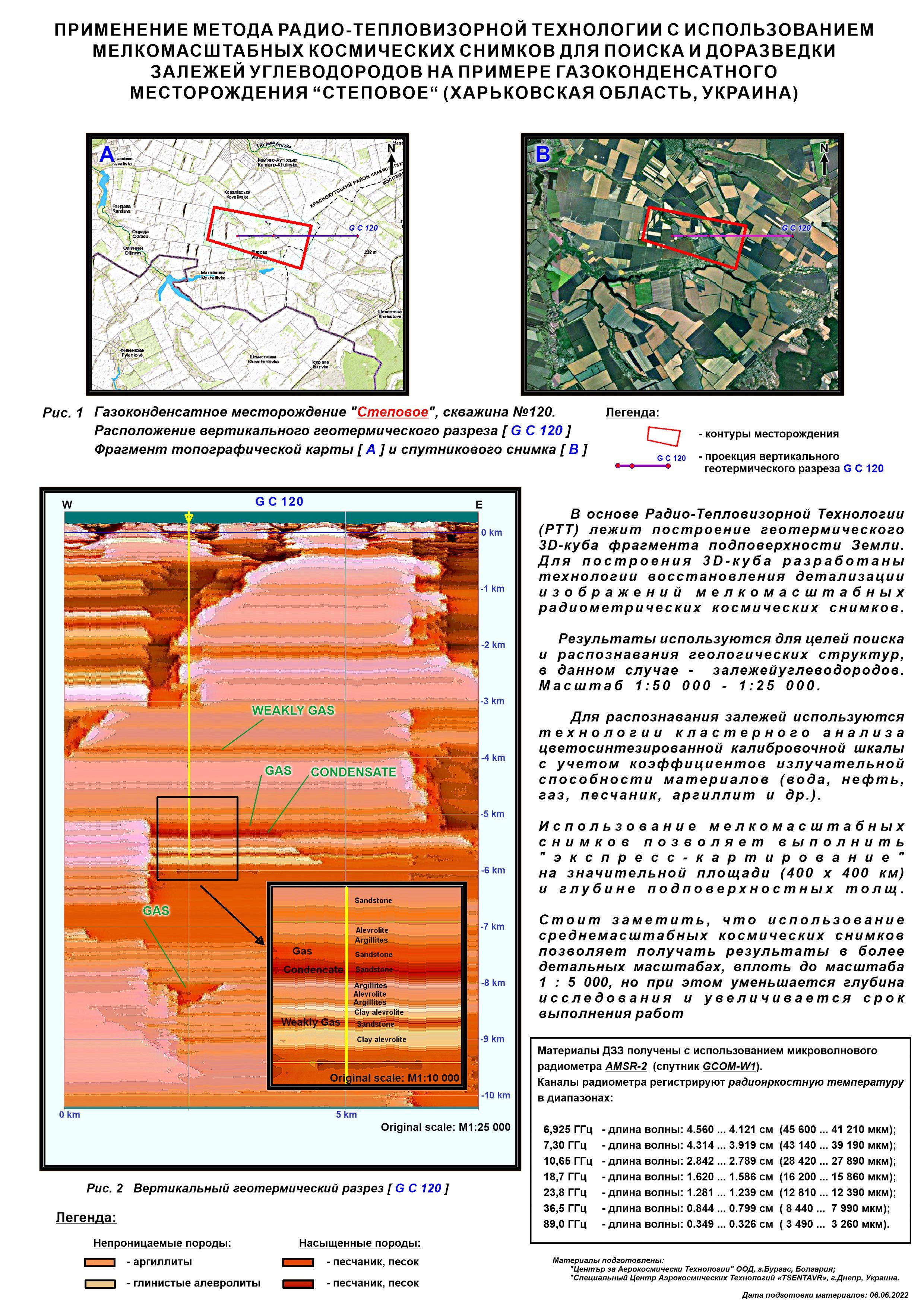
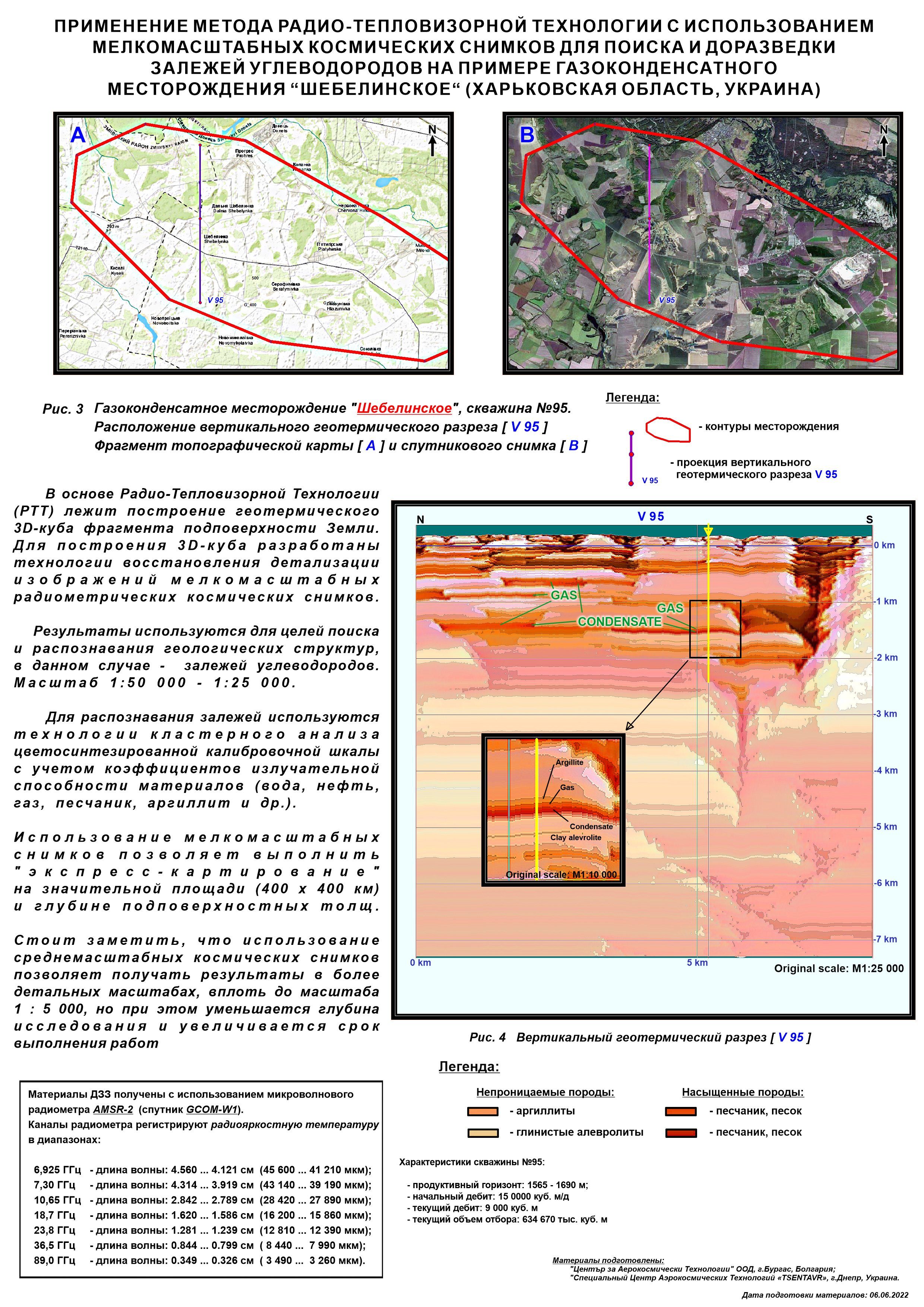
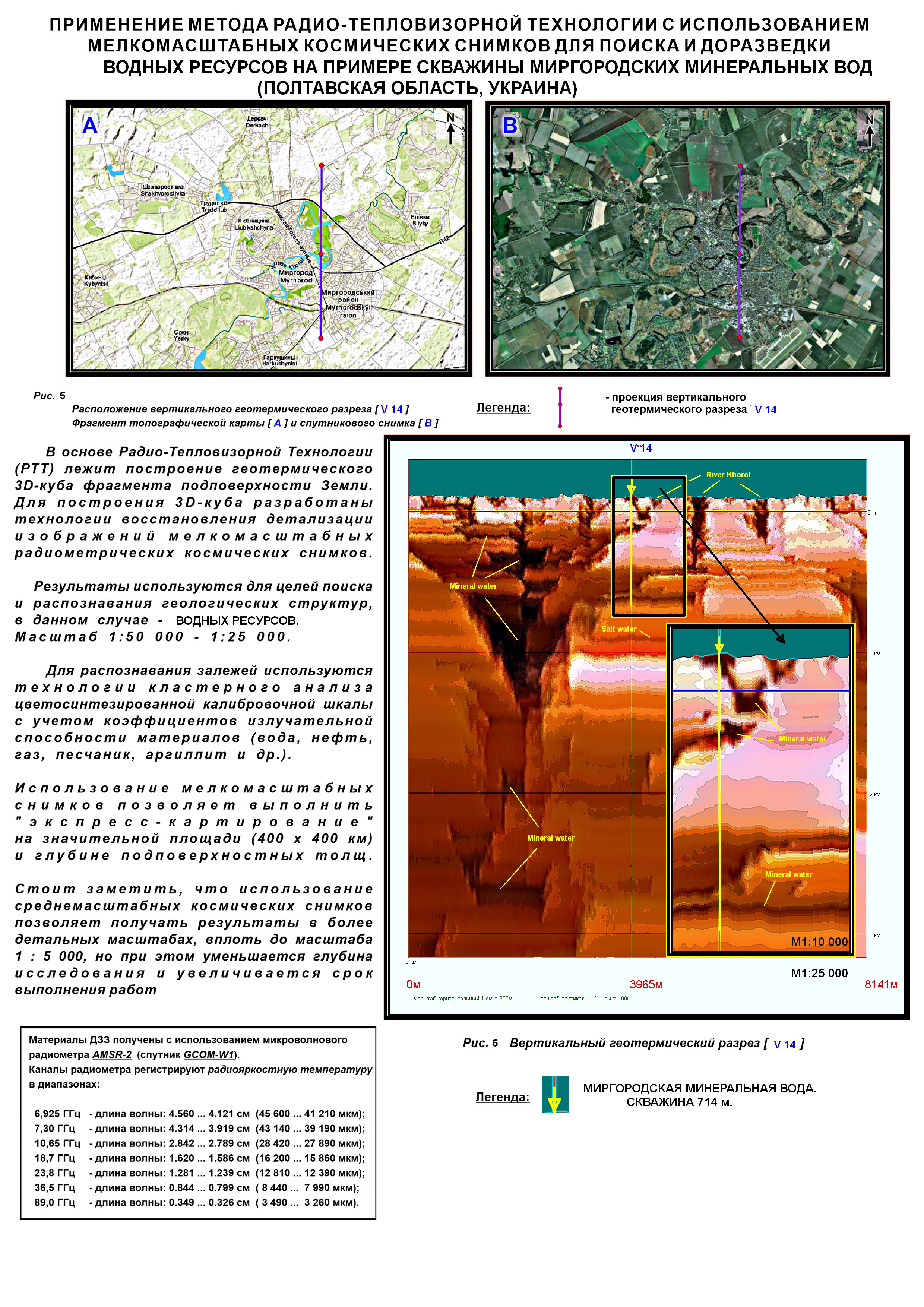
Horizontal "transparency" allows seeing all geological structural heterogeneities, where some elements are recognized as water, gas, oil, ore formations, and the rocks containing them. Places of their highest concentration are visible. Mineral recognition is carried out using calibration classifiers. Geothermal horizontal sections and geothermal vertical sections are constructed.
The technologies use a block-mosaic representation of information (formation of cubic pixel images) with the construction of a geothermal 3D cube of a specified scale, a specified fragment of the Earth's subsurface.
The continuous improvement of the RTT method, both in terms of increasing the depth of research and in increasing the resolution and accuracy of the obtained results, opens up new prospects for forecasting and prospecting for mineral deposits, assessing the seismicity of the territory, fundamental and applied research of the Earth's crust. It opens up prospects for building geodynamic models over time, with the possibility of using operational data for the last decade, in the territory of any fragment of the Earth (monitoring).
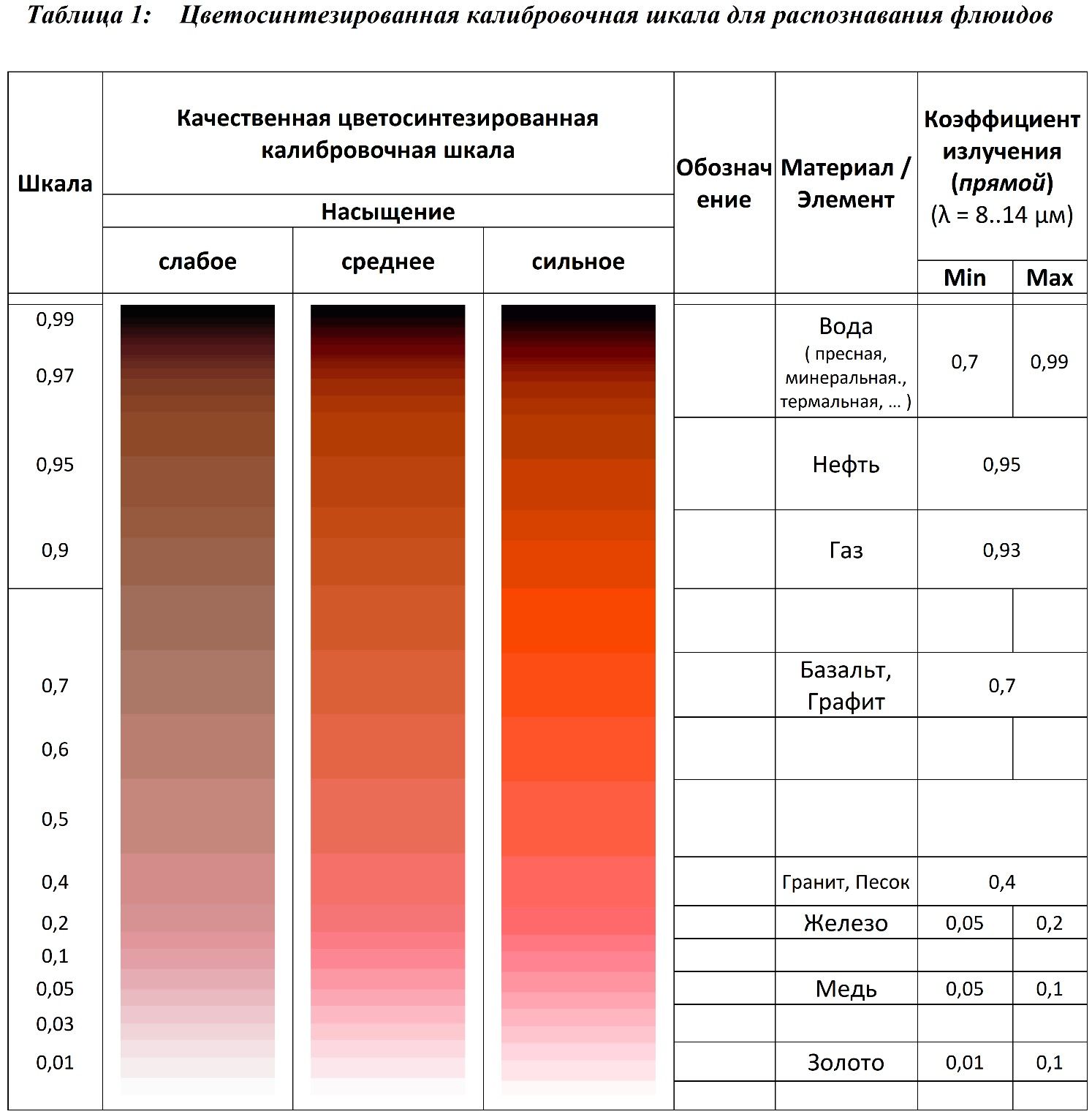
Note: The conditional classification of components is carried out using cluster analysis based on numerical values of color, brightness, saturation, which are part of color-synthesized sections, in comparison with the average coefficients of self-emission of gas, oil, water, and other components adjusting the value of the increment of radiobrightness temperature (ΔT_Y = k * T_E, where ΔT_Y is the increment of radiobrightness temperature (temperature contrast), k is the coefficient of the component's self-emission, T_E is the effective temperature of the component).
Conclusion and Conclusions
The results of the presented work allow us to conclude that the RTT method can have wide applications in geological exploration for the purpose of forecasting and identifying new deposits and re-exploring old ones containing hydrocarbon or ore deposits. Structural heterogeneities are confidently recognized on vertical geothermal sections, allowing the differentiation of linear horizons, which, based on saturation characteristics, can be interpreted as structures saturated with hydrocarbons. Structures are usually limited by a 'cap' and have an impermeable 'basement' at the base. These results are confirmed by data from active wells.
The contours of traps and deposits are identified on geothermal sections, which allows us to recommend this method for work in oil, gas, condensate and other mineral deposits of endogenous origin.
The data from geological studies enable the calibration and interpretation of the model, refining the content of valuable elements in deposits.
The RTT method is environmentally friendly. The technologies enable rapid mapping of extensive territories anywhere on the Earth. It allows optimizing economic and environmental risks in the design and development of deposits, including in hard-to-reach locations on land and sea.
Contacts
"Center of Aerospace Technologies" Ltd
Bulgaria, 8000
Burgas, Antim I, str. 26
Tel:
-
+359 89 462 0030
-
+380 67 632 9101
e-mail:
-
This email address is being protected from spambots. You need JavaScript enabled to view it. -
This email address is being protected from spambots. You need JavaScript enabled to view it.


